• Welcome to Jetboaters.net!

    We are delighted you have found your way to the best Jet Boaters Forum on the internet! Please consider Signing Up so that you can enjoy all the features and offers on the forum. We have members with boats from all the major manufacturers including Yamaha, Seadoo, Scarab and Chaparral. We don't email you SPAM, and the site is totally non-commercial. So what's to lose? IT IS FREE!

    Membership allows you to ask questions (no matter how mundane), meet up with other jet boaters, see full images (not just thumbnails), browse the member map and qualifies you for members only discounts offered by vendors who run specials for our members only! (It also gets rid of this banner!)

    free hit counter

Scarab 195 helm questions

Vetterman

Active Member
Messages
4
Reaction score
1
Points
40
Boat Make
Scarab
Year
2019
Boat Model
Impulse
Boat Length
19
Looking hard at a 195 and I am the type who will often boat in unfamiliar lakes and have always used a chartplotter with a transducer for water depth. Does the helm display already show me water depth or is it deep into other menus so you are always clicking screens to find it. Can I just use a phone with navionics or does anyone suggest bolting my chartplotter to that empty spot beside the display screen
 
i guess it depends where you boat. in my lakes that im in all the time i would rather have a transducer. i have the touch screen on my 195 and i have all the info on my screen at any time. it also has navionics but where i boat on grand lake st marys its about 8 to 10 ft and some places are 15 but most of time time it could be 3 ot 4 feet
 
If your getting the non-touch screen dash, you can display the water depth. But then you will lose the other information you might have had.

The information you can display is:
  • Depth
  • RPM
  • Speed
  • Engine temp
  • Instant fuel flow
  • Average fuel flow
  • Clock
I think that's it but I've not been on the boat for a number of months (storage).

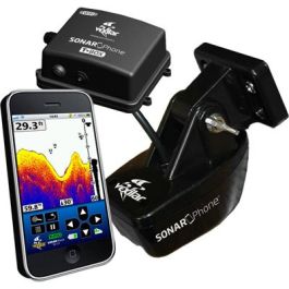
A phone with navionics would just give you the charted depth and wouldn't, I don't think, account for fluctuating water levels unless you got something like this:

 
Personally, I would use a seperate chartplotter to provide all that info and use the boat's system for other functions. Pick up a touch screen chartplotter; they're great.
 
Hey guys, quick side question about the helm info. What is the info displayed beside the compass? Coordinates??
 
Back
Top