• Welcome to Jetboaters.net!

    We are delighted you have found your way to the best Jet Boaters Forum on the internet! Please consider Signing Up so that you can enjoy all the features and offers on the forum. We have members with boats from all the major manufacturers including Yamaha, Seadoo, Scarab and Chaparral. We don't email you SPAM, and the site is totally non-commercial. So what's to lose? IT IS FREE!

    Membership allows you to ask questions (no matter how mundane), meet up with other jet boaters, see full images (not just thumbnails), browse the member map and qualifies you for members only discounts offered by vendors who run specials for our members only! (It also gets rid of this banner!)

    free hit counter
  • Guest, we are pleased to announce that Hydrophase Ridesteady is offering an extra $100 off for JETBOATERS.NET members on any Ridesteady for Yamaha Speed Control system purchased through March 7th, 2025. Ridesteady is a speed control system (“cruise control”) that uses GPS satellites or engine RPM to keep your boat at the set speed you choose. On twin engine boats, it will also automatically synchronize your engines.

    Click Here for more information>Ride Steady group buy for JetBoaters.net members only

    You can dismiss this Notice by clicking the "X" in the upper right>>>>>

Weather App

Bill D

Jetboaters Admiral
Messages
1,790
Reaction score
2,151
Points
302
Location
Prairieville, LA
Boat Make
Yamaha
Year
2011
Boat Model
Limited S
Boat Length
24
I have been using a new(ish) weather app lately and have had really good success with it. I thought I would pass it along in case anyone is interested. This radar app allows you to zoom in very close to the area you are in and see where the storm is and where it is headed.

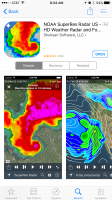
The app is NOAA SuperRes Radar US. It does have a cost, but it has really been worth it. If you get it make sure you go into the settings and turn on "Storm Tracks". It then shows a line of where the storm is headed. I have found it to be super accurate. More than once, we have been able to stay out and enjoy the day as a thunderstorm passed by on a different part of the lake.
IMG_1483.PNG

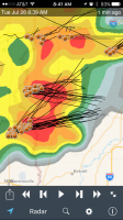
Here you can see how the storm tracks show the direction of movement. It doesn't look good in Linton...
IMG_1484.PNG
 
I've been using this for about 2 years now, although mine is called Hi Def Radar, so I'm wondering if this is a newer version with better graphics.

I can tell you that I love it and it's the first weather app that I go to for accurate storm, rain, lightning strikes, etc.
 
@Bill D Share with us on the FB page :)
 
damn it its for apple... lol
 
Don't see it on the Google App Store....by Shuksan Software anyway. I've been using My Radar for a while....love it.
 
Don't see it on the Google App Store....by Shuksan Software anyway. I've been using My Radar for a while....love it.

Also use My Radar. I find the wind vectors very helpful when planning boating on larger bodies of water
 
Also use My Radar. I find the wind vectors very helpful when planning boating on larger bodies of water
I just went to download this app and realized I already had it. I didn't even know it had a wind vector setting. Maybe they've added it recently? Thanks!
 
I just went to download this app and realized I already had it. I didn't even know it had a wind vector setting. Maybe they've added it recently? Thanks!

I have used it for just about exactly one year, it has had the vectors since I installed it.
 
I use WeatherUnderground (wunderground.com). Their app has storm tracks as well (though you have to go turn them on) and lots and lots of information. And the app is free. Might check it out as well, if you are looking for something.
 
Not trying to hijack this thread but what does everyone use that boats on or near the coast?

I use Google Play Store's - Windfinder Pro and TIDES anyone else?
 
Back
Top